Monday, May 27, 2013

American Armed Forces Museum

Memorial Day weekend we visited the American Armed Forces Museum, and are so glad we did!  It is inspirational not only for the high quality displays, but for the dedication of the volunteers working toward their mission to preserve, protect and perpetuate the honor of those who served!
The museum is small, but houses an extensive collection!  The volunteers research veterans buried in Otero County cemetaries, and have compiled volumes of pictures and information.  They keep flags on the veteran's gravesites throughout the year, and have even replaced worn headstones. 
The uniforms are amazingly crisp, clean, and well displayed.  The care taken with the uniforms honors the military troops that wore them!  
It was brought to our attention that the each individual bar on the left sleeve of this uniform represents 6 months in captivity! 
This is a nice display of field office equipment. 
This is a soldier's bunk and gear. 
We were glad to learn of Sargeant Willie N. Estrada and the work the American Armed Forces Museum volunteers have done to honor his valor and memory.
The museum volunteers are creating a large peace park next to the museum. 
Even in its early stages of development, it is gorgeous! 
The American Armed Forces Museum volunteers have excelled in achieving their mission to preserve, protect and perpetuate the honor of those who served!  Be sure to visit the American Armed Forces Museum while in Alamogordo.  They are located at 144 US Hwy. 82, and are open Tuesday-Saturday 9:00 a.m.-3:00 p.m..  Admission is free. 

Saturday, May 25, 2013

White Sands National Monument, NM

White Sands National Monument is located on Highway 70 15 miles southwest of Alamogordo.  The drive is through flat desert part of which is in the White Sands Missile Range.  At times White Sands National Monument and Highway 70 are closed due to military tests!
After miles of flat desert the white dunes seem to just appear out of nowhere!
Be sure to stop by the visitors center to watch a brief free movie explaining how the white gypsum dunes are formed and about the wildlife that lives on them.   If you visit White Sands National Monument, be sure to check out their website for planned events. They offer a variety of guided hikes during the day and evening, as well as full moon bike rides! Admission to the park was only $3.00 per person and the receipt was good for at least 5 more consecutive days! 
One of the first things you'll notice besides the wide expanse of white are the interesting ripples created by the wind!  Walking on the gypsum barefoot is encouraged!  It is said not to get hot underfoot even in the heat of the day, as it is gypsum and not like regular sand.  It looks very soft, but is surprisingly firm to walk on.
There are other surprises to discover, too! 
As you progress further into the dunes, the road turns from blacktop to plowed gypsum!  It's startling to hear the ranger say that this will happen, but don't worry, as the moistened gypsum is like cement.  The loop through the park is only 8 miles.  The white sands actually cover 300 square miles! 
There is a large picnic area with space age looking shelters!  The strange surroundings combined with these shelters will make you feel like you are on another planet!  There are grills, tables, trash receptacles, and restrooms, so enjoy a picnic while at the park!  A tent camping area is also available within the park!  An overnight stay would be an interesting experience! 
Bring a sled and enjoy some dune sledding on the dune of your choice!  The visitor center gift shop sells new disc sleds for $15 and will buy them back at a portion of the original price.  Used sleds are also sold. 
Here is a synopsis of what we learned about the formation of the dunes and the plants that survive on them.  Gypsum leaches into the water flowing down out of the gypsum rich mountains.  The water settles into land locked lakes that eventually dry out.  Gypsum crystals are left behind.  The strong desert winds break the crystals into flakes and blows them along breaking them into increasingly smaller sizes.  The crystals start out opaque to clear, and take on the white color from the scuffing that occurs as they bounce along.
Don't be fooled by the plants you see atop the dunes!  They may appear that their seeds blew in and established themselves there.  The truth is that many grew with the dune as it increased in size.  Some of these Yuccas have plant growth going 30 feet deep!  When the dune eventually moves on, the Yucca is left without support for its full height and will topple over and die.  
Some plants get their roots solidly deep into a dune.  When the dune blows onward, the plant is able to sustain itself by pulling moisture into its own foothold of sand!  The dunes within the interior of the park are reported to advance up to 15 feet a year!  The perimeter dunes only move a few inches due to the surrounding desert vegetation. 
Regardless of understanding how the white sand dunes came to be, we left the park in awe of a place like this existing on Earth!          


Thursday, May 23, 2013

Alamogordo Museum of History

The Alamogordo Museum of History is small, but packed full of nice displays.  Admission is free, which fits our budget perfectly!  We enjoyed our visit and highly recommend you stop in, too!  It is located in the same building as the Visitor's Center.
One of the main attractions at the museum is this 47 star flag commemorating the addition of New Mexico as a state on January 6, 1912.  Because Arizona became the 48th state the very next month on February 14th, an official 47 star flag was never adopted.  According to the brochure flags are only adopted in July.  The 47 star flag came about when a flag making company jumped the gun in production!  This 47 star flag and only one other is known of.  The other flag is housed at the Palace of Governors in New Mexico's capital city of Santa Fe.  
This museum visit seemed to be an exercise in vocabulary and photography techniques!  Here is a display of atlatls.  There's a scrabble word for you!  An atlatl is an Aztec word for spear thrower.  I wasn't aware there were spear throwers!  A spear thrower or atlatl facilitates the throwing of a spear by making it go further and faster!  Not really sure how these atlatls work, though.   
This is a nice piece for grinding corn.  It is called a metate y mano.  The metate is the rock slab and the mano is the hand held grinding stone.  The small round stone is lighter in weight and smoother.  It appeared as though it would be used to grind the corn into a powder.  
It's a concretion!  Is that a fancy word for petrified dinosaur cow pie???
This is an Internet picture of Bowling Ball Beach in Mendocino County, California.  These are concretions!  A concretion is defined as a compact mass of sedimentary rock formed by the precipitation of mineral cement within the spaces between the sediment grains.  Concretions form within layers of sedimentary strata that have already been deposited.  The concretionary cement often makes the concretion harder and more resistant to weathering than the host stratum.  Concretions are most often ovoid or spherical, but can be irregular in shape, too.  Concretions!  That's definitely something I hadn't heard of!    
I'm proud of capturing this picture covered in glass!  You can't put your camera against the glass to cut out glare like when taking a picture of a room display through Plexiglas.  The overhead fluorescent lights created a wide bright band across the glass and other images were reflected in the glass when shooting straight into the picture.  The same happened shooting from the side.  Technique:  Squat down low and shoot upward!
 
This picture is depicting Buffalo Soldiers.  After the Civil War, 12,000 Black American soldiers fought in the regular army in the Indian wars of the West.  They were assigned to four all black regiments, the 9th and 19th Calvary, and the 24th and 25th Infantry.  The nickname Buffalo Soldiers was a badge of honor conferred by their Indian foes.  The name referred to the troop's fighting spirit, which was like the sacred buffalo in stamina and strength!            
This is a very classy desk set complete with quill pen holder, ink well, blotter, and ash tray!  Are you of an age to have used this type pen and a jar of ink at school?  I'm 61 and I never used this type pen when in school, but got to use the quill pen with its own ink cartridge for awhile!  We felt very clever saving on the cost of ink cartridges, by refilling the pen's cartridge using a jar of ink and a hypodermic needle!  The desks in the elementary school I attended still had a hole in the desk tops for an ink well!          
I remember them all!  It's kind of scary, when things you grew up with start showing up in museums of history!  Roy says not to get any ideas about wearing a "Fragile, do not touch sign" like we see on things of our age on display!  That man reads my mind!  ;-) 

Tuesday, May 21, 2013

The Shroud of Turin Exhibit & Museum


When Roy and I discovered this museum in Alamogordo, we were hesitant to go to it, but we are so glad we did!  The presentation and displays were excellent!  We learned a lot!
The Shroud of Turin is the cloth Jesus was wrapped in at his burial.  The flax linen cloth is 14' long by 3.5' wide.  There is a frontal and dorsal image.  The back lit shroud on display is a full-size photographic image.  It looks very real.  The original shroud is kept in Italy.  The presenter told us of the shroud's history citing locations, events, and dates.  Here are a few of the things we learned:  1. Whipping and crucifying together was not typically done. Each alone was sufficient to kill a person.  2.  The marks on the body, as shown in the cloth, are consistent with a Roman flagrum.  (A flagrum is pictured in front of the shroud.)  3.  The blood marks on the shroud are truly blood and of a type consistent with the people of the geographical area and time period.  4.  The blood marks show that the blood ran the direction expected for the reported tortures.  5.  The wrists were considered part of the hand at that time and the nail mark went through at that point.  6.  Only 4 fingers show on the image of the hands.  The thumbs are not seen, as nailing through the wrist would cause them to fall limp into the palms.  7.  The triangles on the shroud are repairs from where a hot piece of metal fell on the folded shroud and burned through.  8.  The shroud was in a building fire and has water damage marks.          
Over 50 modern day scientists were called together to analyze the shroud.  Many were from New Mexico.  It's said that the scientists felt such skepticism regarding the shroud that they thought they would complete their analysis within minutes, but studied it for 120 hours (5 24 hour days)!  With equipment designed to detect dimension, they learned that the shroud projects a 3 dimensional image!  They don't know why!  The photograph of the shroud projects a 3D image on the monitor, and will also do it with your cell phone!  A reverse black/white negative of the shroud will also project a 3D image!  Other types of photos do not project a 3D image!    
There were lots of nice displays that a person could spend hours reading.  Depicted in the top black framed pictures are the Groom, Texas life size sculptures showing a sequence of events in the crucifixion.  The museum is very interesting and has free admission.  We highly recommend it!  
 

Monday, May 20, 2013

Alamogordo, NM

We pulled into Shady Grove RV Park on Hwy. 54 just outside of Alamogordo on May 15th.  The monthly rate with full hook-ups is only $245.00.  Electric, cable, and high speed Internet is included in that rate!  We got this great lot next to the office!  This is the view out our picture window.  Odie is allowed to play inside the fenced office area!  I can sit in one of the rocking chairs on the porch and read while he explores!  Odie's routine so far is to make at least one lap around the building, before he retires for a nap!  There are lots of places to take the dogs for walks.
Capturing a city is always difficult, but here is a glimpse showing how closely Alamogordo is situated to the mountains.  Alamogordo is located in the Tularosa Basin, with Highway 54/70 as the main boulevard running north/south through the center of the community.  Alamogordo, locally called Alamo, is at an elevation of 4,380 feet and was reported in 2012 to have a population of 30,403.  Holloman Air Force Base, the German Air Force Tactical Training Center, and White Sands National Monument are located just outside of town.  The community is home to the New Mexico School for the Blind and Visually Impaired.  Alamogordo has a branch of New Mexico State University, a museum of space history, an Imax theater, and a theater for the performing arts.
On the corner of US 54/70 and Tenth Street is Founder's Park.  It is a nice park honoring the community's founders through bronze sculptures.  In the same vicinity is the city zoo, the museum of history, the visitor's center, and a toy train museum.
This is a nice painting at Founder's Park representing the Hispanic influence on the settling of Alamogordo.
A key figure in settling the area is Oliver Lee.  Nearby Oliver Lee State Park was named in his honor.  We look forward to exploring the area and getting to know Alamogordo!

Wednesday, May 15, 2013

Three Rivers Petroglyph Site, NM

We arrived at Three Rivers Petroglyph Site on the 11th and stayed through the 14th.  It is located only 28 miles from Carrizozo.  Three Rivers consists of the petroglyph site and one privately owned gift shop.  The closest community is Tularosa, which is 17 miles away.  Be sure to arrive with supplies for your stay.
 
 
Here is an overview of the campground at Three Rivers Petroglyph Site.  That's our rig to the back of the lot.  Campsites without any hook-ups are only $7.00 a night. There is fresh water on the premises and modern restrooms.  They have two pull though sites with water and electric for $18.00 a night.  A dump station isn't available.  There is another campground 6 miles further in, but we're told the road to it is a little rough.  It was mentioned to us that the campground is often looking for workkampers to host the park for three to six months out of the year!  It definitely would be a place to get away from it all! 
The campground and petroglyph site is located in the Tularosa Basin.  It looks like a land that time forgot!  It wouldn't be at all surprising to see a dinosaur here!  Every evening as dusk falls, I get a shiver up my spine being outdoors for the shortest of durations, as I half expect a sabertooth tiger or at least a mountain lion to pounce! 
Throughout our stay it has been trying to rain.  We get rolls of thunder, a sprinkle to light shower, and then back to blue skies! 
Despite the recent rain sprinkles great dust devils swirl off in the distance.  We estimate this dust devil to be four miles away!  There is something about the spot where this dust devil appeared, as they seemed to spawn in that location often. 
The desert vegetation is more spread out and with fewer cacti then other parts of the desert we've been in so far.  The dogs have been able to walk outside without collecting goatheads in their pads!  That's a major plus!  The plants are showing lots of flower buds, but no real show of color yet.  This is the northernmost region of the Chihuahuan Desert.  The desert is pleasant to walk through, but one still has to be mindful to watch for rattlesnakes.  Roy and I plan to each carry an ace bandage with us, as our first aid for snake bites.  From my research on survival in the wilds, the only thing you should do for a rattlesnake bite is to wrap the limb to lessen swelling and get to a doctor within 14 hours for the anti-venom!  Basically, we're told that rattlesnakes will move away from people given the chance, but that it is the accidental stepping on one that will get you in trouble.  I feel it is best to keep pets from snooping under bushes and in rocky crevices. 
Late in the day of our arrival, we decided to make the one mile round trip walk to the ruins of an ancient community.  It's best to walk before or after the heat of the day. 
This is the base of what is referred to as a pit home.  This reconstructed base is about 17 feet in diameter.  This is one of the earliest type of homes built by the Jornado Mogollan people 1,000 years ago.  It was cool to see what appeared like a shelf ridge carved into the inside of the circle.  This structure would give some coolness in the Summer and warmth in the Winter.    
The next step in homes were rock structures.  This is also a reconstruction.  To the back of the structure beyond the two larger rocks is a small round room that would have been a pantry.
This is the foundation for the most recent home design, which was the adobe surface home.  They often consisted of several small rooms.
We were so psyched after our walk to the ruins that we were ready to take-on the one mile round trip walk up the hill to where some of the petroglyphs are located.  Although the park advertises that there are 21,000 petroglyphs, they are spread out over 50 acres.  This mound is said to contain the best petroglyphs.  Don't let the small size of this mound fool you!  Once you reach the top of this hill, it continues upward to another ridge, and then another ridge, and beyond!
Kudos to whatever agency built the paths!  They made the climb seem relatively easy, not to say an out of shape person such as myself wouldn't huff and puff a bit!  A woman who had knee replacement surgery made it up and we met an older man on top the first ridge with two canes!
The paths are relatively wide, have a nice solid driveway mix base in areas where it helps, and long platform style steps.  Pets are not allowed on the trails.   
We made it to the top of the first ridge on our first night in camp!  This is the next section at the top of the ridge.  Isn't the path between the rocks intriguing!  I wanted to forge on so badly, but we opted to save it for another day.
The next day we forged past our previous day's climb and entered the path between the ridge of black rocks shown in the previous picture!  Roy's plan to expend our energy going directly to the top and then meander back down was superb!  At the "top"  was a nice shelter, but of course, the top of the hill was just a false peak again!  The trail meandered upward into a less rocky and desert environment.
This is the view from my climb beyond the top looking back towards the shelter!  The mound you see is to the front of the main petroglyph mound.  It is said to have pottery shards on it.  We had hoped to climb it, but will have to explore it on another trip through, when we are in better physical condition.  There doesn't seem to be groomed trails to it. 
This is a mound to the back of the main petroglyph ridge.  We talked about hiking to it.  We were told it doesn't have petroglyphs on it.  At first glance the park seems small and could be seen with just a day pass.  I agree that a person could get a good overview while here on a day pass, but with a longer stay might enjoy hiking to the outlying mounds for a look around.  It's a great place for getting into shape! 
Beautiful!  It appears to be a big horn sheep with arrows in its side. 
This looks like a man being attacked by a bear at night.  See the moon?  I like the way the man's expression of horror can almost be seen! 
Another ram!  Nice wool depicted! 
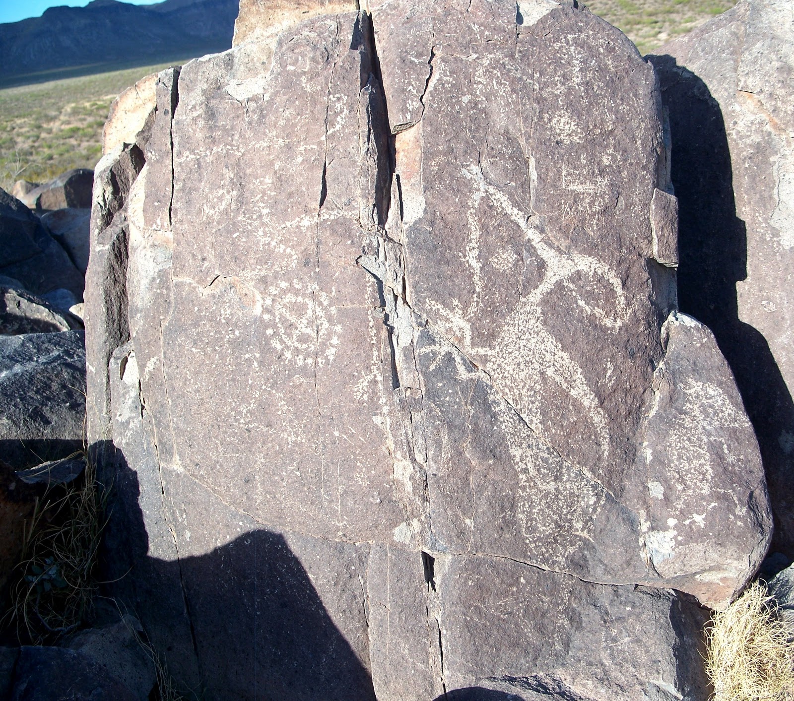
I like this petroglyph!  I'm not sure what it is, but I think of it as a dog with a couple of toys.  That might be a snake petroglyph to the right. 
I read that petroglyphs are made by one rock being used as a chisel and another rock pounding the chisel rock like a hammer to chip away the natural patina of the rock being carved on.  The age of a petroglyph can be judged by how faded it is.  Over time the rock will repatinate itself.  The reformation of the patina must be an extremely slow process given the age of the petroglyphs!  Did you know petroglyph literally means rock carving?  I didn't either! 
 
I think this must be some poor guy in trouble, although he looks a bit like a badger to me!
Here are a few animals and a sun medicine wheel. 
A deer and more! 
I love this ram's head! 
This looks to me like a guy being attacked by a wolf and some other creature running  away. 
This is a medicine wheel.  I read that all tribes have them.  They have a lot of meaning within them.  Here is just a bit of what I know about them.  The four spokes represent the four directions.  The four sections represent the four seasons, the four stages of life, four aspects of a person's being (i.e. physical, spiritual, emotional,...) different clans, and much more.  During my time living near the Ojibway and Chippewa Indians, I noted the sections of their medicine wheel to have four colors:  white, yellow, red, and black.     
Here is a modern rock sculpture that I found visually pleasing!  Rock art might just be in our natures!